A friend from the Toronto group bike ride community directed me to Jeff Allen’s intringuing and beautiful cartographic work.
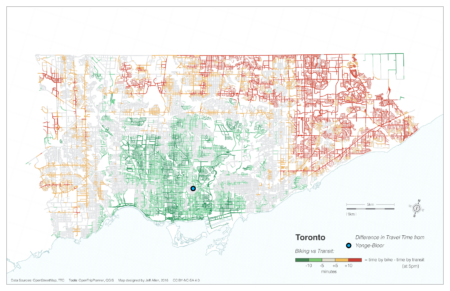
One especially striking map – which supports my view that bicycling has become the best and fastest form of transport in Toronto – shows which areas it is faster to reach from Yonge-Bloor by bike than by transit during rush hour:
You can get a long way! Straight north to York Mills. Southwest past the mouth of the Humber. Southeast past Tommy Thomson Park and into Scarborough.
The map is from 2016, but I would imagine things are worse now with transit underfunding and all the slowdown zones, plus all the streets blocked up by summer construction.


Doug Ford’s bill to limit new bike lanes will also ‘review’ existing ones
https://www.thestar.com/politics/provincial/doug-fords-bill-to-limit-new-bike-lanes-will-also-review-existing-ones/article_fe7bf592-8fc2-11ef-9ed3-6708bbbff2ad.html